Precision Farming in Agriculture

Precision farming is one of the major changes to agriculture in our lifetime as it has prospects for investment and improved livelihoods for farmers. Over the years, farmers have stuck to the orthodox system of farming using traditional knowledge to warn of drought, praying and waiting for rain and allowing nature to take its course in their affairs..
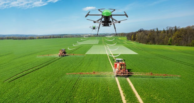
However with Precision Farming on board, farmers can manage their farm from digital devices and remotely control tractors that have already been installed with GPS, and instruct distant crop watering systems to turn on and off. Sensors can be placed in fields to measure temperature (air and soil), and humidity. Drones and satellites can also be used to collect and analyze data, which will aid in informing farmers on fertilizing and tending to their crops.
Precision Farming is a farming management concept based on observing, measuring and responding to inter and intra-field variability in crops. The goal of precision agriculture research is to define a decision support system (DSS) for whole farm management with the goal of optimizing returns on inputs while preserving resources.
Instead of discarding local knowledge, precision farming augments it and provide cost-effective and accurate ways to predict and protect the growth of agricultural crops. Farmers in most developed countries are using technology to look at data on weather, soil quality, air quality and crop progress. They make use of real-time information collected by control centres to decide when to plant, fertilise and harvest. Technology promises change for agriculture that saves time and money for farmers.
Precision farming has four stages;
Data Collection: This enables the farmer compare information gathered from soils, residual nitrogen analysis, and information on previous crops and soil resistivity. It can be done in two ways;
The field is delineated using an in-vehicle GPS receiver as the farmer drives a tractor around the field.
See also: Gracia Farms Looks to Partner with Meet the Farmers Conference for Sustainable Agriculture
The field is broken down on a basemap gotten from aerial or satellite imagery. The base images must have the right level of resolution and geometric quality to ensure that geolocation is sufficiently accurate.
Variables: intra and inter field variability results from a number of factors; climatic conditions (hail, drought, rain etc.), soil (texture, depth, nitrogen levels), cropping practices (no-till farming), weeds and disease. Permanent indicators provide farmers with information about the main environmental constants. Point indicators allow them to track a crop’s status, to see whether diseases are developing or if the crop is suffering from water stress, nitrogen stress, or lodging, whether it has been damaged by ice and so on.
This information may come from weather stations and other sensors (soil electrical resistivity, detection with the naked eye, satellite imagery, etc.). Soil resistivity measurements combined with soil analysis make it possible to measure moisture content. Soil resistivity is also a relatively simple and cheap measurement
Strategies: With soil, farmers can use two strategies to adjust field inputs;
- Predict Approach: this is the analysis of static indicators (soil, resistivity, field history etc.) during the crop cycle.
- The Control Approach: the information from static indicators is regularly updated during the crop cycle by, sampling, remote sensing, proxy detection, aerial or satellite remote sensing decision based on crop simulation models.
Implementing practices: New information and communication technologies (NICT) make field-level crop management easier and operational for farmers. Application of crop management decisions calls for agricultural equipment that supports variable-rate technology (VRT), like; varying seed density along with variable-rate application (VRA) of nitrogen and phytosanitary products.
Precision agriculture uses the technology on agricultural equipment (e.g. tractors, sprayers, harvesters, etc.) Positioning system (e.g. GPS receivers that use satellite signals to precisely determine a position on the globe) Geographic information systems (GIS), i.e., softwares that makes sense of all the available data; variable-rate farming equipment (seeder, spreader).
Benefits of Precision Farming
- It allows farmers monitor the soil and determine physicochemical parameters. The ideal conditions for plant growth can be achieved just by placing sensors (electrical conductivity, nitrates, temperature, evapotranspiration, radiation, leaf and soil moisture, etc.)
- It aids farmers in obtaining data in real time. The application of sensing devices in your fields will allow you monitor and offer real time data which will ensure an updated status of the field.
- It provides better information for management decisions.
- It saves time and costs, as it reduces fertilizer and chemical application costs and reduce pollution through less use of chemicals.
- It provides better farm records that is essential for sale and succession.
- It also aids; less fuel use, less soil compaction, less hired labor requirement and more timely sowing.
As good as precision farming is, the farmer should do a proper research before venturing into one. As misuse of these products and lack of awareness of the field parameters can decrease productivity and endanger the environmental balance in the cultivation area.
Farmers and landowners who decide to use technology to manage their fields should consider precision farming as it seems to bring many benefits, and ultimately increase of profit.


